
2 min read
Sols 4297-4299: This Way to Tungsten Hills

Earth planning date: Friday, Sept. 6, 2024
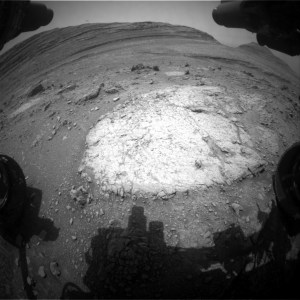
Curiosity completed an impressive 60-meter drive (about 197 feet) across the channel floor within Gediz Vallis and parked along the edge of a shallow linear depression. Just about 20 meters (66 feet) away, an intriguing dark, textured rock named “Tungsten Hills” is the destination for our weekend drive and our contact science on Monday. Today I served as the “Keeper of the Plan” for the Geology theme group and worked with the science team to compile a variety of contact science and targeted science in this three-sol plan.
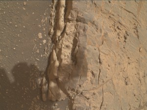
Contact science in our immediate workspace includes a joint effort by MAHLI and APXS to characterize a gray rock with two targets named “Big Baldy” and “Big Bird Lake.” ChemCam focused its Laser Induced Breakdown Spectroscopy (LIBS) instrument on a rock with a reddish coating, “Purple Creek,” and a light-toned rock, “Garlic Meadow,” to determine their chemical composition. ChemCam included a long distance RMI image of the yardang unit that caps Mount Sharp as well as a standard post-drive AEGIS activity, which allows autonomous target selection for upcoming geochemical spectrometry.
The Mastcam team assembled several beautiful mosaics to document Curiosity’s surroundings. One mosaic will extend the imaging of the current workspace and is planned at dusk to take advantage of the diffuse lighting. Two separate mosaics, one of which is in stereo, will characterize the floor of the depression in front of Tungsten Hills to investigate the exposed light rocks and document depositional processes. Finally, a stereo mosaic will image Tungsten Hills and the surrounding terrain in advance of our approach over the weekend.
With the weekend plan in place the science team will now patiently wait for data to be returned and for planning to resume on Monday!
Written by Sharon Wilson Purdy, Planetary Geologist at the Smithsonian National Air and Space Museum


